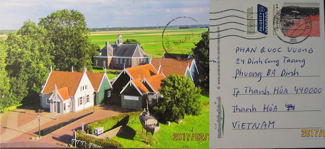
Sent: ?
Arrived: 10 Feb 2017
Wadden Sea
UNESCO site
Date of Inscription: 2009
The Wadden Sea is the largest unbroken system of intertidal
sand and mud flats in the world, with natural processes undisturbed throughout
most of the area. The 1,143,403 ha World Heritage property encompasses a
multitude of transitional zones between land, the sea and freshwater
environment, and is rich in species specially adapted to the demanding
environmental conditions. It is considered one of the most important areas for
migratory birds in the world, and is connected to a network of other key sites
for migratory birds. Its importance is not only in the context of the East
Atlantic Flyway but also in the critical role it plays in the conservation of
African-Eurasian migratory waterbirds. In the Wadden Sea up to 6.1 million
birds can be present at the same time, and an average of 10-12 million pass
through it each year.
Criterion (viii): The Wadden Sea is a depositional coastline
of unparalleled scale and diversity. It is distinctive in being almost entirely
a tidal flat and barrier system with only minor river influences, and an
outstanding example of the large-scale development of an intricate and complex
temperate-climate sandy barrier coast under conditions of rising sea-level.
Highly dynamic natural processes are uninterrupted across the vast majority of
the property, creating a variety of different barrier islands, channels, flats,
gullies, saltmarshes and other coastal and sedimentary features.
Criterion (ix): The Wadden Sea includes some of the last
remaining natural large-scale intertidal ecosystems where natural processes
continue to function largely undisturbed. Its geological and geomorphologic
features are closely entwined with biophysical processes and provide an
invaluable record of the ongoing dynamic adaptation of coastal environments to
global change. There are a multitude of transitional zones between land, sea
and freshwater that are the basis for the species richness of the property. The
productivity of biomass in the Wadden Sea is one of the highest in the world,
most significantly demonstrated in the numbers of fish, shellfish and birds
supported by the property. The property is a key site for migratory birds and
its ecosystems sustain wildlife populations well beyond its borders.
Criterion (x): Coastal wetlands are not always the richest
sites in relation to faunal diversity; however this is not the case for the
Wadden Sea. The salt marshes host around 2,300 species of flora and fauna, and
the marine and brackish areas a further 2,700 species, and 30 species of
breeding birds. The clearest indicator of the importance of the property is the
support it provides to migratory birds as a staging, moulting and wintering
area. Up to 6.1 million birds can be present at the same time, and an average
of 10-12 million each year pass through the property. The availability of food
and a low level of disturbance are essential factors that contribute to the key
role of the property in supporting the survival of migratory species. The
property is the essential stopover that enables the functioning of the East
Atlantic and African-Eurasian migratory flyways. Biodiversity on a worldwide
scale is reliant on the Wadden Sea.
Sent:?
Arrived: 10 Feb 2017
Schokland and Surroundings
UNESCO site
Date of Inscription: 1995
The struggle of the people of the Netherlands against water
has endured, for more than six thousand years, and still continues today;
without constant vigilance, more than half the present area of the country
would be entirely submerged or subject to periodic inundation. Schokland was a
peninsula that by the fifteenth century had become an island. Occupied and then
abandoned as the sea encroached, it had to be evacuated in 1859. Following the
impoldering of the Zuider Zee, however, it has formed part of the land
reclaimed from the sea since the 1940s. Schokland has vestiges of human
habitation going back to prehistoric times. It symbolizes the heroic, age-old
struggle of the people of the Netherlands against the encroachment of the
water. As a result of the colossal reclamation programme that began in the
early years of the 20th century, Schokland and the settlement mounds and other
human interventions that surround it stand as mute testimony to the skill and
fortitude of the Dutch people in the face of this never-ceasing natural threat.
The contours of the former island of Schokland above the
flat lands of the reclaimed Noordoostpolder are still easy to trace in the
topography within the former island — there are four large village terps, all
of them protected archaeological sites. A fifth such site includes traces of
Neolithic, Bronze Age and Iron Age settlements.
The remains of dykes and terps located outside the present
island reflect the former contours of the island and the land that has been
lost over the course of time. Also located outside the present island, but
within the boundaries of the World Heritage property, are more than 160
archaeological sites with remnants of prehistoric occupation. A church and
church ruins, residential and commercial buildings, barns, a former harbour,
and land division patterns (both old and new) go to complete the story of
Schokland.
The area provides exceptional evidence of a cultural
tradition of island-dwellers threatened by the water and ultimately evacuated;
the first residents on the land reclaimed from the sea cultivated and developed
that new land. The area is an exceptional example of a traditional type of
settlement and land use that is representative of cultures, primarily when
these have become vulnerable due to the influence of irreversible change.
Thank you Maik!


Aucun commentaire:
Enregistrer un commentaire