Dear, I open for direct swap. You can contact me via email : chiphoi001@yahoo.com. I collect: - Lunar new year; - Lady slipper & Dancing lady orchid; - Tom of Finland; - Inge Look Aunties; - Blue Cats World Trip; - Erotic (about men); - Van Gogh card from museum

presentation

My postcard album for swap
If you find something interesting in my album and want to swap, you can drop me some lines with your album. Thank you.
Affichage des articles dont le libellé est Unesco site. Afficher tous les articles

lundi 26 mars 2018

Chile, UNESCO site: Rapa Nui National park ; My new country in my collection,


This one is my first mail from Chile. So happy that I can take off another country from my missing list. And I was a bi surpris when i get it. My last Peru card took more than 6 months to arrive but the Chile one took only a month. They are from the same continent but not the same qualitty of service. 


Thank you so much Misao for this suppor.


Rapa Nui National Park

 UNESCO site

Date of Insscription: 1995

Rapa Nui National Park is a protected Chilean wildlife area located in Easter Island, which concentrates the legacy of the Rapa Nui culture. This culture displayed extraordinary characteristics that are expressed in singular architecture and sculpture within the Polynesian context. Easter Island, the most remote inhabited island on the planet, is 3,700 kilometres from the coast of continental Chile and has an area of 16,628 hectares while the World Heritage property occupies an area of approximately seven thousand hectares, including four nearby islets.  

The island was colonized toward the end of the first millennium of the Christian era by a small group of settlers from Eastern Polynesia, whose culture manifested itself between the eleventh and seventeenth centuries in great works such as the ahu –ceremonial platforms- and carved moai - colossal statues- representing ancestors. Rapa Nui National Park most prominent attributes are the archaeological sites.  It is estimated that there are about 900 statues, more than 300 ceremonial platforms and thousands of structures related to agriculture, funeral rites, housing and production, and other types of activities.  Prominent among the archaeological pieces are the moai that range in height from 2 m to 20 m and are for the most part carved from the yellow–brown lava tuff, using simple picks (toki) made from hard basalt and then lowered down the slopes into previously dug holes. There are many kinds of them and of different sizes: those in the process of being carved, those in the process of being moved to their final destinations –the ahu-, those being torn down and erected.  The quarries (Rano Raraku and others) are invaluable evidence of the process of their carving.  The ahu vary considerably in size and form; the most colossal is the Ahu Tongariki, with its 15 moai.  There are certain constant features, notably a raised rectangular platform of large worked stones filled with rubble, a ramp often paved with rounded beach pebbles, and levelled area in front of the platform. Also extremely valuable are the rock art sites (pictographs and petroglyphs), which include a large variety of styles, techniques and motifs. Other archaeological sites are the caves, which also contain rock art.  There is also a village of ceremonial nature named Orongo which stands out because of its location and architecture.  While it has not attracted as much attention, the housing and productive structures are of extreme interest.

According to some studies, the depletion of natural resources had brought about an ecological crisis and the decline of the ancient Rapa Nui society by the 16th century, which led to decline and to the spiritual transformation in which these megalithic monuments were destroyed.  The original cult of the ancestor was replaced by the cult of the man-bird, which has as exceptional testimony the ceremonial village of Orongo, located at the Rano Kau volcano.  Fifty-four semi-subterranean stone-houses of elliptical floor plans complement this sacred place, profusely decorated with petroglyphs alluding to both the man-bird and fertility.  This cult would see its end in the middle of the nineteenth century.
Colonization, the introduction of livestock, the confinement of the original inhabitants to smaller areas, the dramatic effect of foreign diseases and, above all, slavery, reduced the population of Rapa Nui to little more than a hundred.  Currently, the island is inhabited by descendants of the ancient Rapa Nui as well as immigrants from diverse backgrounds, accounting for a significant mixed population.

Critère (i): Rapa Nui National Park contains one of the most remarkable cultural phenomena in the world. An artistic and architectural tradition of great power and imagination was developed by a society that was completely isolated from external cultural influences of any kind for over a millennium.

Criterion (iii): Rapa Nui, the indigenous name of Easter Island, bears witness to a unique cultural phenomenon. A society of Polynesian origin that settled there c. A.D. 300 established a powerful, imaginative and original tradition of monumental sculpture and architecture, free from any external influence. From the 10th to the 16th century this society built shrines and erected enormous stone figures known as moai, which created an unrivalled landscape that continues to fascinate people throughout the world.

Criterion (v): Rapa Nui National Park is a testimony to the undeniably unique character of a culture that suffered a debacle as a result of an ecological crisis followed by the irruption from the outside world. The substantial remains of this culture blend with their natural surroundings to create an unparalleled cultural landscape.
Source: UNESCO.ORG


jeudi 15 juin 2017

Portugal, UNESCO site: Convent of Christ in Tomar;


Thank you Martinha!

Convent of Christ in Tomar

UNESCO site
Date of Insscription: 1983


Originally designed as a monument symbolizing the Reconquest, the Convent of the Knights Templar of Tomar (transferred in 1344 to the Knights of the Order of Christ) came to symbolize just the opposite during the Manueline period – the opening up of Portugal to other civilizations.

Germany, UNESCO site:Classical Weimar;


Thank you Melanie!

Classical Weimar

UNESCO site
Date of Insscription: 1998


In the late 18th and early 19th century the small Thuringian town of Weimar witnessed a remarkable cultural flowering, attracting many writers and scholars, notably Goethe (1749-1832) and Schiller (1759-1805). This development is reflected in the high quality of many buildings and parks in the surrounding area.

It was in the lifetime of Duchess Anna Amalia (1739-1809) that Weimar’s Classical period began. She appointed the poet Christoph Martin Wieland (1733-1813) as tutor to her sons in 1772. It was after Carl August (1757-1828) had succeeded to the Duchy that Johann Wolfgang Goethe settled in the town (1775). Johann Gottfried Herder (1744-1803) came to Weimar in the following year. The high point of the town's cultural influence resulted from the creative relationship between Goethe and Friedrich Schiller that began in 1794 and was intensified when Schiller moved to Weimar in 1799.

The World Heritage properties comprises twelve separate buildings or ensembles: Goethe's House and Goethe´s Garden and Garden House; Schiller's House; Herder Church, Herder House and Old High School; Residence Castle and Ensemble Bastille; Dowager's Palace (Wittumspalais); Duchess Anna Amalia Library; Park on the Ilm with the Roman House; Belvedere Castle and Park with Orangery; Ettersburg Castle and Park; Tiefurt Castle and Park; and Historic Cemetery with Princes´ Tomb.

Criterion (iii): The high artistic quality of the public and private buildings and parks in and around the town testify to the remarkable cultural flowering of the Weimar Classical Period.

Criterion (vi): Enlightened ducal patronage attracted many of the leading writers and thinkers in Germany, such as Goethe, Schiller, and Herder to Weimar in the late 18th and early 19th century, making it the cultural centre of the Europe of the day.

Source: unesco.org

Spain, UNESCO site: Catalan Romanesque Churches of the Vall de Boí;


Thank you Josep& Assumpta!


Catalan Romanesque Churches of the Vall de Boí

UNESCO site
Date of Insscription: 2000

The narrow Vall de Boí is situated in the high Pyrénées, in the Alta Ribagorça region and is surrounded by steep mountains. Each village in the valley contains a Romanesque church, and is surrounded by a pattern of enclosed fields. There are extensive seasonally-used grazing lands on the higher slopes

Source: unesco.org

Spain, UNESCO site: Poblet Monastery;


Thank you, Josep & Assumpta!

Poblet Monastery

UNESCO site
Date of Insscription: 1991

Poblet Monastery is located in the south of Catalonia, in the northeast of the Iberian Peninsula, in the municipality of Vimbodí. It is one of the largest and most complete Cistercian abbeys in the world. It was built in the 12th to 15th centuries around a church that dates to the 13th century. It is impressive for the majesty of its architecture and includes a fortified royal residence as well as the pantheon of the kings and queens of Catalonia and Aragon.

The Monastery is structured as three enclosures, surrounded by a defensive wall. The first outer enclosure contains buildings from the 16th century, such as storehouses, workshops, housing for lay workers and other premises connected with the financial life of the community. This enclosure also contains the Gothic chapel of Sant Jordi, built in 1452. The fortified Golden Door gives access to the second enclosure, made up of the Plaça Major, or Main Square, around which stand the remains of the hospital for the poor, the Romanesque chapel of Santa Caterina and the treasury. The third and innermost enclosure is fortified and includes the church, cloister and monastic rooms.

The defensive wall is crenulated and is strengthened by a series of square or polygonal towers, two of which flank the Royal Doorway.

The church is on a three-aisled basilical plan with transepts and an apsidal east end with ambulatory. The ceiling consists of a pointed vault in the central aisle and ribbed vaults on the side aisles. Notable features of the interior of the church are the Renaissance retable and the royal tombs. Mature Gothic forms dominate the great cloister. The earliest parts of the structure are the south gallery and the lavabo around which the oldest buildings of the complex (12th and 13th centuries) are distributed: the chapter house, the refectory, the kitchen and calefactory, the library, the old scriptorium, and the dormitory, built over the library and chapter house.

Poblet Monastery is extraordinarily important in terms of art, culture, history and spirituality and for its key role in the repopulation and agricultural exploitation of New Catalonia under the Crown of Aragon. Its library and scriptorium were well known from the 13th century onwards for their works on law and history, and the monastery served as a custodian of the history of the dynasty as well as the Royal remains.

It is also one of the most important and sumptuous Cistercian monasteries where the functional plan and spirit of the monastery are present throughout its structure. The spiritual quality of the life of Poblet Monastery has also made it a very important centre in the life of the country, from the time of its foundation until the present day.

Criterion (i): Poblet is a unique artistic achievement and one of the most perfect expressions of Cistercian style in the 12th, 13th and 14th centuries. The abbey contains masterpieces from every period such as the great alabaster altarpiece by Damià Forment (1529).

Criterion (iv): The Santa Maria of Poblet complex presents a unique blend of architectural forms generally reserved for distinct applications. Poblet has served as one of the largest and most complete of the Cistercian abbeys, as a massive military complex, and as a royal palace, residence and pantheon..
Source: unesco.org

mercredi 14 juin 2017

Canada, UNESCO site: Old Town Lunenburg;


Thank you Axia!


Old Town Lunenburg

UNESCO site
Date of Insscription: 1995

Old Town Lunenburg is the best surviving example of a planned British colonial settlement in North America. Established in 1753, it has retained its original layout and overall appearance, based on a rectangular grid pattern drawn up in the home country. The inhabitants have safeguarded the town’s identity throughout the centuries by preserving the wooden architecture of the houses and public buildings, some of which date from the 18th century and constitute an excellent example of a sustained vernacular architectural tradition. Its economic basis has traditionally been the offshore Atlantic fishery, the future of which is highly questionable at the present time.
Criterion (iv): Old Town Lunenburg is a well-preserved example of 18th century British colonial urban planning, which has undergone no significant changes since its foundation, and which largely continues to fulfil the economic and social purposes for which it was designed. Of special importance is its diversified and well-preserved vernacular architectural tradition, which spans over 250 years.
Criterion (v): Old Town Lunenburg is an excellent example of an urban community and culture designed for and based on the offshore Atlantic fishery which is undergoing irreversible change and is evolving in a form that cannot yet be fully defined..

Source: unesco.org

Italy, UNESCO site: Church and Dominican Convent of Santa Maria delle Grazie with “The Last Supper” by Leonardo da Vinci;


Thank you Chiara!


Church and Dominican Convent of Santa Maria delle Grazie with “The Last Supper” by Leonardo da Vinci

UNESCO site
Date of Insscription: 1980

The refectory of the Convent of Santa Maria delle Grazie in Milan forms an integral part of this architectural complex, begun in 1463 and reworked at the end of the 15th century by Bramante. On the north wall is The Last Supper, the unrivalled masterpiece painted between 1495 and 1497 by Leonardo da Vinci, whose work was to herald a new era in the history of art. The complex, including the Church and Convent, was built from 1463 onwards by Guiniforte Solari, and was afterwards considerably modified at the end of 15th century by Bramante, one of the masters of the Renaissance. Bramante structurally enlarged the church and added large semi-circular apses, a wonderful drum-shaped dome surrounded by columns, and a spectacular cloister and refectory.

The painting was commissioned in 1495 and completed in 1497. The representation by Leonardo da Vinci depicted the moment immediately after Christ said, “One of you will betray me”. Leonardo rejected the classical interpretation of the composition and had Jesus in the midst of the Apostles; he also created four groups of three figures on either side of Christ. The 12 Apostles reacted in differing ways; their movements and expressions are magnificently captured in Leonardo's work. The genius of the artist is seen especially in the use of light and strong perspective. Unfortunately, Leonardo did not work in fresco but in tempera on a two-layered surface of plaster that did not absorb paint. It was as early as 1568 when Vasari first pointed out problems with this painting technique.

The Last Supper, which Leonardo da Vinci painted in the refectory of the Dominican convent of Santa Maria delle Grazie, is undisputedly one of the world’s masterpieces of painting. Its unique value, which over the centuries has had immense influence in the field of figurative art, is inseparable from the architectural complex in which it was created.

Criterion (i): The Last Supper is a timeless and unique artistic achievement of Outstanding Universal Value.

Criterion (ii): This work has highly influenced not only the development of one iconographic theme, but also the entire development of painting. Heydenreich wrote about the “superdimension” of its painted bodies in relation to space. It is one of the first classic paintings that focuses on a precise and very short moment of time, instead of a long one. After five centuries, the Last Supper is one of most reproduced and copied paintings, and its creation in 1495-1497 is considered to have heralded a new phase in the history of art.

Source: unesco.org

Italy, UNESCO site: Rhaetian Railway in the Albula / Bernina Landscapes;


Thank you Chiara! Now I have completed this site from both sides.

Rhaetian Railway in the Albula / Bernina Landscapes

UNESCO site
Date of Insscription: 2008

The Rhaetian Railway in the Albula/Bernina Landscapes represents an exemplary railway development for the disenclavement of the Central Alps at the beginning of the 20th century. The railway’s socio-economic consequences were substantial and lasting for mountain life, the interchange of human and cultural values, and changes in the relationship between man and nature in the West. The Rhaetian Railway offers a wide diversity of technical solutions for the establishment of the railway in often severe mountain conditions. It is a well designed construction that has been realised with a high degree of quality and it has remarkable stylistic and architectural homogeneity. The railway infrastructure moreover blends in particularly harmoniously with the Alpine landscapes through which it passes..

Source: unesco.org

Germany, UNESCO site: Aachen Cathedral,


Thank you Merja!

Aachen cathedral

UNESCO site
Date of Insscription: 1978

It is Emperor Charlemagne´s own Palatine Chapel, which constitutes the nucleus of the Cathedral of Aachen, located in western Germany. The construction of the chapel between 793 and 813 symbolises the unification of the West and its spiritual and political revival under the aegis of Charlemagne. Originally inspired by the churches of the eastern part of the Holy Roman Empire, the octagonal core was splendidly enlarged in the Middle Ages. In 814, Charlemagne was buried here.

Charlemagne made the Frankish royal estate of Aachen, which had been serving a spa ever since the first century, his favourite abode. The main buildings of the Imperial Palace area were the Coronation Hall (aula regia – located in today´s Town Hall) and the Palace Chapel – now Aachen Cathedral. The Palatine Chapel is based on an octagonal ground plan, which is surrounded by an aisle and by tribunes above, and roofed with a dome. Facing the altar, the Emperor sat on the gallery; the Carolingian stone throne was the coronation seat of the kings of the Holy Roman Empire of German Nation from the Middle Ages until 1531. The chapel itself is easily recognizable from later additions by its distinctive structure. An atrium on the western side and a portico led to the imperial apartments. The Gothic choir and a series of chapels that were added throughout the Middle Ages created the composite array of features that characterised the cathedral.

The interior is punctuated on the lower storey by round arches set upon eight ample pillars, and on the upper storey by a gallery with eight Carolingian bronze gates. The high dome gathers light from eight open-arched windows above the drum; it was originally entirely covered with a large mosaic depicting Christ Enthroned, in purple robes and surrounded by the Elders of the Apocalypse. The present-day mosaic dates back to 1880/1881. The interior of the chapel is embellished by antique columns that Charlemagne probably ordered to be brought from Rome and Ravenna. Despite the subsequent additions, the Palatine Chapel constitutes a homogeneous nucleus.

The Cathedral Treasury in Aachen is regarded as one of the most important ecclesiastical treasuries in northern Europe; the most prominent inventory items are the cross of Lothar (about 1000 AD), made from gold and inlaid with precious stones, the dark-blue velvet chasuble with embroidered pearls, a reliquary-bust of Charlemagne made from silver and gold, and a marble sarcophagus decorated with a relief of the Abduction of Proserpine, which once contained the body of Charlemagne.

Criterion (i): With its columns of Greek and Italian marble, its bronze doors, the largest mosaic of its dome (now destroyed), the Palatine Chapel of Aachen, from its inception, has been perceived as an exceptional artistic creation. It was the first vaulted structure north of the Alps since Antiquity.

Criterion (ii): Bearing the strong imprint of both Classic and Byzantine tradition this chapel remained, during the Carolingian Renaissance and even at the beginning of the medieval period, one of the prototypes of religious architecture which inspired copies or imitations.

Criterion (iv): The Palatine Chapel of Charlemagne is an excellent and distinctive example of the family of aulian chapels based on a central plan with tribunes.

Criterion (vi): The construction of the Chapel of the Emperor at Aachen symbolised the unification of the West and its spiritual and political revival under the aegis of Charlemagne. In 814, Charlemagne was buried here, and throughout the Middle Ages until 1531, the German emperors continued to be crowned at Aachen. The collection of the treasury of the Cathedral is of inestimable archaeological, aesthetic and historic interest..

Source: unesco.org

Germany, UNESCO site: Palaces and Parks of Potsdam and Berlin;


Thank you Svenja1!

Palaces and Parks of Potsdam and Berlin

UNESCO site
Date of Insscription: 1990

The Palaces and Parks of Potsdam and Berlin (Sanssouci) represent a self-contained ensemble of architecture and landscape gardening in the 18th and 19th centuries. This ensemble, having an outstanding artistic rank, has its origin in the work of the most significant architects and landscape gardeners of their time in Northern Germany - G.W. von Knobelsdorff (1699-1753), C. von Gontard (1731-1791), C.G. Langhans (1732-1808), K.F. Schinkel (1781-1841), P.J. Lenné (1789-1866) and their co-operators. Together with highly imaginative sculptors, painters, craftsmen, building workers, and gardeners, they created Sanssouci, the New Garden, the Park of Babelsberg, and other grounds in the surrounding area of Potsdam as an overall work of art of high quality, European rank, and international standing.

The World Heritage property enfolds the Palaces and Parks of Potsdam and Berlin including buildings, parks, and designed spaces, which are intuitively, territorially and historically aligned with Sacrow Castle and Park and the Sauveur Church.

The cultural landscape with its parks and buildings was designed and constructed between 1730 and 1916 in a beautiful region of rivers, lakes, and hills. The underlying concept of Potsdam was carried out according to Peter Joseph Lenné’s plans, which he designed after the mid-1800s, to transform the Havel landscape into the cultural landscape it is today. These designs still determine the layout of Potsdam’s cultural landscape. The ensemble of parks of Potsdam is a cultural property of exceptional quality. It forms an artistic whole, whose eclectic nature reinforces its sense of uniqueness.

In Potsdam, the World Heritage property includes Sanssouci Park, the Lindenallee Avenue west of the New Palace, the Former Gardener’s Training School, former Railway Station of the Emperor and its environs, Lindstedt Palace and its low-lying surroundings, the Seekoppel paddock, the Avenue to Sanssouci, the Voltaireweg Avenue as a connection between Sanssouci Park and the New Garden, the New Garden, the so-called Mirbach Wäldchen Grove and the link between Pfingstberg Hill and the New Garden, the Villa Henkel with Garden, Pfingstberg Hill, the garden at the Villa Alexander, Babelsberg Park, the approaches to Babelsberg Park, the Babelsberg Observatory, Sacrow Park, the Royal Forest around the village of Sacrow, and the Russian colony Alexandrowka with the Kapellenberg, the artificial Italian village of Bornstedt and the artificial Swiss village in Klein-Glienicke. In Berlin, it includes Glienicke Park, Böttcherberg Hill with the Loggia Alexandra, the Glienicke Hunting Lodge, and the Peacock Island (including all buildings).

Criterion (i): The ensemble of the Palaces and Parks of Potsdam is an exceptional artistic achievement whose eclectic and evolutive features reinforce its uniqueness: from Knobelsdorff to Schinkel and from Eyserbeck to Lenné, a series of architectural and landscaping masterpieces have been built within a single space, illustrating opposing and reputedly irreconcilable styles without detracting from the harmony of a general composition that has been designed progressively over time. The beginning of the construction of Friedenskirche in 1845 is a symbol of deliberate historicism: this "Nazarene" pastiche of San Clemente Basilica in Rome commemorates the laying, on 14 April 1745, of the first stone for Sanssouci, the Rococo palace par excellence.

Criterion (ii): Potsdam-Sanssouci - frequently called the "Prussian Versailles" - is the crystallization of a great number of influences from Italy, England, Flanders, Paris, and Dresden. A synthesis of art trends in European cities and courts in the 18th century, the castle and the park offer new models that have greatly influenced the development of the monumental arts and the organization of space east of the Oder.

Criterion (iv): Potsdam-Sanssouci is an outstanding example of architectural creations and Landscaping development associated with the monarchic concept of power within Europe. By the vastness of the program, these royal ensembles belong to the very distinct category of princely residences, such as Würzburg and Blenheim (included on the World Heritage List in 1981 and 1987 respectively). The bombing of 14 April 1945 has made it impossible to nominate to the World Heritage List the urban ensemble developed by Frederick William I in two stages: the "first new town", from 1721 to 1725, and the "second new town", beginning in 1733.

Source: unesco.org

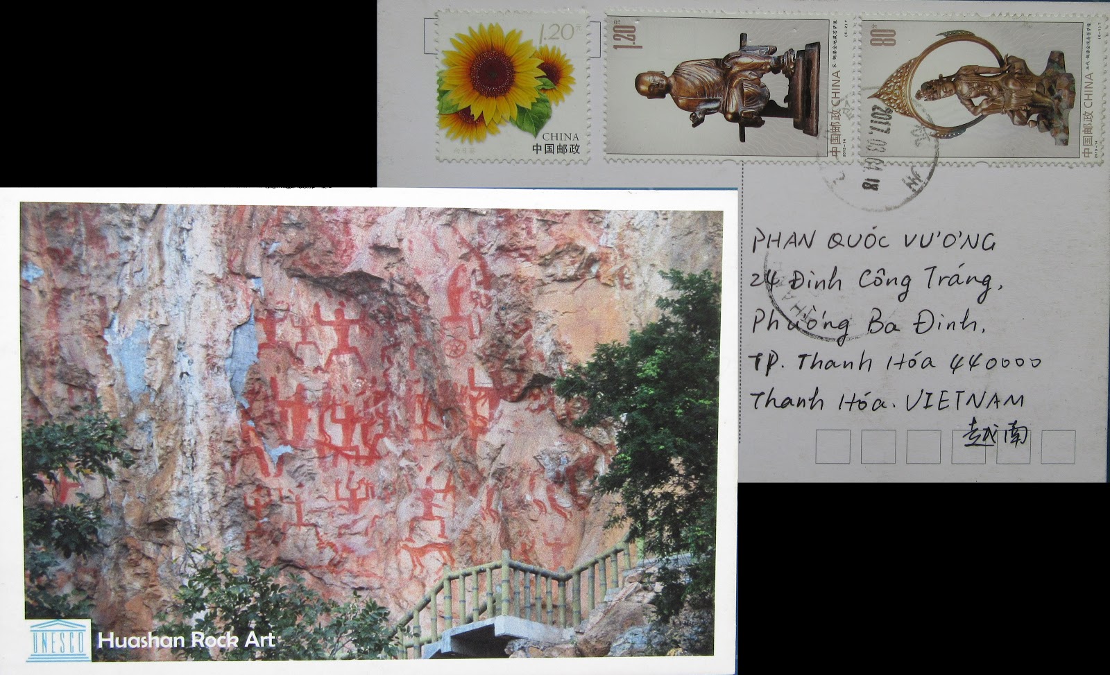
China, UNESCO site: Zuojiang Huashan Rock Art Cultural Landscape;


Thank you Chenzhu!

Zuojiang Huashan Rock Art Cultural Landscape

UNESCO site
Date of Insscription: 2016

Dating from around the 5th century BCE to the 2nd century CE, 38 sites of rock art and their associated karst, riverine and tableland landscape depict ceremonies that have been interpreted as portraying the bronze drum culture once prevalent across southern China. Located on steep cliffs cut through the karst landscape by the meandering Zuojiang River and its tributary Mingjiang River, the pictographs were created by the Luoyue people illustrating their life and rituals.

Criterion (iii): The Zuojiang Huashan Rock Art Cultural Landscape, with its special combination of landscape and rock art, vividly conveys the vigorous spiritual and social life of the Luoyue people who lived along the Zuojiang River from the 5th century BCE to the 2nd century CE. It is now the only witness to the tradition.

Criterion (vi): The images of Zuojiang Huashan depicting drums and related elements are symbolic records directly associated with the bronze drum culture once widespread in the region. Today bronze drums are still respected as symbols of power in southern China...

Source: unesco.org

China, UNESCO site: Wulingyuan Scenic and Historic Interest Area;


Thank you Zihu!

Wulingyuan Scenic and Historic Interest Area

UNESCO site
Date of Insscription: 1991

Wulingyuan is an island of nature within a heavily populated agricultural region. A spectacular area stretching some 26,400ha in China’s Hunan Province, the site is dominated by more than 3,000 narrow quartz sandstone pillars, many over 200m high. Nestled within its towering peaks lie ravines and gorges with streams, pools and waterfalls, two large natural bridges, and some 40 caves. Impressive calcite deposits are a notable feature within these caves. In addition to the striking beauty of the landscape, including spectacular jagged stone peaks, luxuriant vegetation cover and clear lakes and streams, the region is also home to a number of endangered plant and animal species.

Criterion (vii): The huge number of sandstone columns and peaks—more than 3,000—are spectacular. These, coupled with other land forms (natural bridges, ravines, waterfalls, streams, pools and caves) and dense broadleaf forest, present an aesthetically beautiful landscape enhanced by the mists and clouds which frequently shroud the site. There are more than 40 caves and two huge natural stone bridges, one of which rises 357 m above the valley floor.

At time of evaluation it was also noted that with additional information there could also be justification for inscribing this property under criterion (x), as the site provides important habitat for a number of threatened plant and animal species such as dhole, Asiatic black bear and Chinese water deer..

Source: unesco.org

China, UNESCO site: Mount Qingcheng and the Dujiangyan Irrigation System;


Thank you Zihu!


Mount Qingcheng and the Dujiangyan Irrigation System

UNESCO site
Date of Insscription: 2000

The Dujiangyan irrigation system, located in the western portion of the Chengdu flatlands at the junction between the Sichuan basin and the Qinghai-Tibet plateau, is an ecological engineering feat originally constructed around 256 BC. Modified and enlarged during the Tang, Song, Yuan and Ming dynasties, it uses natural topographic and hydrological features to solve problems of diverting water for irrigation, draining sediment, flood control, and flow control without the use of dams. Today the system comprises two parts: the Weir Works, located at an altitude of 726m, the highest point of the Chengdu plain 1km from Dujiangyan City, and the irrigated area. Three key components of the Weir Works control the water from the upper valley of the Minjiang River: the Yuzui Bypass Dike, the Feishayan Floodgate, and the Baopingkou Diversion Passage. Together with ancillary embankments and watercourses including the Baizhang Dike, the Erwang Temple Watercourse and the V-Shaped Dike, these structures ensure a regular supply of water to the Chengdu plains. The system has produced comprehensive benefits in flood control, irrigation, water transport and general water consumption. Begun over 2,250 years ago, it now irrigates 668,700 hectares of farmland.

Mount Qingcheng, dominating the Chengdu plains to the south of the Dujiangyan Irrigation System, is a mountain famous in Chinese history as the place where in 142 CE the philosopher Zhang Ling founded the doctrine of Chinese Taoism. Most of the essential elements of Taoism culture are embodied in the teachings of Taoism that emanated from the temples that were subsequently built on the mountain during the Jin and Tang dynasties. The mountain resumed its role as the intellectual and spiritual centre of Taoism in the 17th century. The eleven important Taoist temples on the mountain reflect the traditional architecture of western Sichuan and include the Erwang Temple, the Fulong Temple, the Changdao Temple built over the place where Zhang Ling preached his doctrines, and the Jianfu Palace (formerly the Zhangren Temple).

Criterion (ii): The Dujiangyan Irrigation System, begun in the 2nd century BCE, is a major landmark in the development of water management and technology, and is still discharging its functions perfectly.

Criterion (iv): The immense advances in science and technology achieved in ancient China are graphically illustrated by the Dujiangyan Irrigation System.

Criterion (vi): The temples of Mount Qingcheng are closely associated with the foundation of Taoism, one of the most influential religions of East Asia over a long period of history.

Source: unesco.org

China, UNESCO site: Lushan National Park;


Thanks chenzhan!

Lushan National Park,

UNESCO site
Date of Insscription: 1996

Mount Lushan is located in Jiujiang City, Jiangxi Province. The property area of Lushan National Park occupies a total area of 30,200 hectaresand its highest Peak, Hanyang Peak, is 1,474 meters above sea level. Bordered on the north by the Yangtze River and on the south by Poyang Lake, Mount Lushan presents an integral scene of river, hills and lake, the beauty of which has attracted spiritual leaders, scholars, artists and writers for over 2,000 years. More than 200 historic buildings are located in the Lushan National Park; complexes of prayer halls that have been rebuilt and extended many times to create an ongoing centre for study and religion. These include the Buddhist East Grove Temple complex begun by Huiyuan in 386 CE; the West Grove Pagoda begun around 730 CE; the Temple of Simplicity and Tranquility built during the Tang dynasty as the repository of Taoist scriptures, and the White Deer Cave Academy originally established in 940 CE and revived in the late 12th century during the Song dynasty when Zhu Xi instigated the spread of Confucius’ political and ethical teaching. This complex continued to be extended up to the 19th century to include many temples, study halls and libraries. Other important features include the stone single-span Guan Ying Bridge of 1,015 CE and more than 900 inscriptions on cliffs and stone tablets. In addition there are around 600 villas built by Chinese and foreign visitors in the late 19th and 20th centuries, when the area became a popular resort and was, during the 1930s and 40s the official Summer Capital of the Republic of China.  The villas reflect various architectural fashions and are laid out within the landscape in accordance with Western planning concepts prevalent at the time.
Mount Lushan has an important place in Chinese history and culture. It is an outstanding representative of Chinese landscape culture, as well as a remarkable model of Chinese academy-based education, and a focal point for the integration of Chinese and Western cultures, once acting as the cultural center of southern China. The significant cultural developments and political events occurring over the course of Lushan’s history have influenced the course of Chinese history.
The natural beauty of Lushan is perfectly integrated with its historic buildings and features, creating a unique cultural landscape which embodies outstanding aesthetic value powerfully associated with Chinese spiritual and cultural life.  Combining nature and culture, Mount Lushan represents the Chinese national spirit and epitomizes its cultural life.

Criterion (ii): The building and layout of temples and educational buildings within the scenic landscape at Lushan have created a cultural landscape exhibiting an interchange of values over a long period from the Han dynasty in the late 3rd century BCE through to the early 20th century.

Criterion (iii): The Lushan landscape has inspired philosophy and art. The selective and sensitive integration of high quality cultural properties into this landscape is exceptional testimony to Chinese appreciation of the harmonious interaction of natural beauty and culture.

Criterion (iv): The group of ancient buildings at the White Deer Cave Academy represents the architectural model for Chinese traditional academies. Guanyin Bridge, a stone arch bridge with a rabbet and mortise structure, has played a very important role in Chinese bridge building. The groups of modern villas are a testament to the penetration of Western culture into China’s hinterlands in the late 19thcentury to the middle of the 20th century.


Criterion (vi): Huiyuan, who created the Pure Land Sect of Buddhism at Lushan’s Donglin Temple, inaugurated an era of the localization of Buddhism in China. Zhu Xi revitalized the White Deer Cave Academy, making it the model for the popularization of Song and Ming Dynasty Confucian idealist philosophy and the model of academy-based education. His influence continued over 700 years of Chinese history after the Song Dynasty. The Confucian idealist philosophy as interpreted by Zhu Xi, and his educational pattern, spread as far as Japan, Korea, Indonesia and elsewhere, and has played a very important role in the global history of education.

Source: unesco.org

Sweden, UNESCO site: Hanseatic Town of Visby;


Thanks Merja!

Hanseatic Town of Visby

UNESCO site
Date of Insscription: 1995

A former Viking site on the island of Gotland, Visby was the main centre of the Hanseatic League in the Baltic from the 12th to the 14th century. Its 13th-century ramparts and more than 200 warehouses and wealthy merchants' dwellings from the same period make it the best-preserved fortified commercial city in northern Europe..

Source: unesco.org

Sweden, UNESCO site: Laponian Area;


Thanks Merja!

Laponian Area

UNESCO site
Date of Insscription: 1996

The Arctic Circle region of northern Sweden is the home of the Saami, or Lapp people. It is the largest area in the world (and one of the last) with an ancestral way of life based on the seasonal movement of livestock. Every summer, the Saami lead their huge herds of reindeer towards the mountains through a natural landscape hitherto preserved, but now threatened by the advent of motor vehicles. Historical and ongoing geological processes can be seen in the glacial moraines and changing water courses.

Source: unesco.org

Sweden, UNESCO site: Skogskyrkogården;


Thank you Merja!


Skogskyrkogården

UNESCO site
Date of Insscription: 1994

This Stockholm cemetery was created between 1917 and 1920 by two young architects, Asplund and Lewerentz, on the site of former gravel pits overgrown with pine trees. The design blends vegetation and architectural elements, taking advantage of irregularities in the site to create a landscape that is finely adapted to its function. It has had a profound influence in many countries of the world..
Source: unesco.org


India, UNESCO site: Rock Shelters of Bhimbetka;


Thank you Sita!

Rock Shelters of Bhimbetka

UNESCO site
Date of Insscription: 2003

The Rock Shelters of Bhimbetka are in the foothills of the Vindhyan Mountains on the southern edge of the central Indian plateau. Within massive sandstone outcrops, above comparatively dense forest, are five clusters of natural rock shelters, displaying paintings that appear to date from the Mesolithic Period right through to the historical period. The cultural traditions of the inhabitants of the twenty-one villages adjacent to the site bear a strong resemblance to those represented in the rock paintings.

Source: unesco.org

Finland, UNESCO site: Fortress of Suomenlinna;


Thank Shaun!

Fortress of Suomenlinna

UNESCO site
Date of Insscription: 1991

Suomenlinna (Sveaborg) is a sea fortress, which was built gradually from 1748 onwards on a group of islands belonging to the district of Helsinki. The work was supervised by the Swedish Admiral Augustin Eherensvärd (1710-1772), who adapted Vauban’s theories to the very special geographical features of the region. The landscape and the architecture of the fortress have been shaped by several historic events. It has served to defend three different sovereign states over the years: the Kingdom of Sweden, the Russian Empire and most recently the Republic of Finland.

Covering an area of 210 ha and consisting of 200 buildings and 6 km of defensive walls, the fortress stretches over six separate islands. The original fortress was built using local rock and fortified with a system of bastions over varied terrain. The purpose of the fortress was originally to defend the Kingdom of Sweden against the Russian Empire and to serve as a fortified army base, complete with a dry dock. Sandbanks, barracks and various other buildings were added during the 19th-century Russian period. The defensive system was adapted to match the requirements of a modern fortress and developed in the 19th century using contemporary fortification equipment.

After Finland gained independence in 1917, the fortress was renamed Suomenlinna (or Fortress of Finland) and served as a garrison and a harbour. The military role of the fortress declined after World War II, and in 1973 the area was converted for civilian purposes. Since then, buildings have been renovated to serve as apartments as well as workspaces, to house private and public services, and for cultural purposes.

Today, Suomenlinna is one of the most popular tourist attractions in Finland and constitutes a district of Helsinki with 850 inhabitants.

Criterion (iv): In the history of military architecture, the Fortress of Suomenlinna is an outstanding example of general fortification principles of the 17th and 18th centuries, notably the bastion system, and also showcases individual characteristics..

Source: unesco.org

mardi 13 juin 2017

Germany, UNESCO site:Zollverein Coal Mine Industrial Complex in Essen;


Than you Melaine!

Zollverein Coal Mine Industrial Complex in Essen

UNESCO site
Date of Insscription: 2001

The Zollverein XII Coal Mine Industrial Complex is an important example of a European primary industry of great economic significance in the 19th and 20th centuries. It consists of the complete installations of a historical coal-mining site: the pits, coking plants, railway lines, pit heaps, miner’s housing and consumer and welfare facilities. The mine is especially noteworthy of the high architectural quality of its buildings of the Modern Movement.
Zollverein XII was created at the end of a phase of political and economic upheaval and change in Germany, which was represented aesthetically in the transition from Expressionism to Cubism and Functionalism. At the same time, Zollverein XII embodies this short economic boom between the two World Wars, which has gone down in history as the “Roaring Twenties.” Zollverein is also, and by no means least, a monument of industrial history reflecting an era, in which, for the first time, globalisation and the worldwide interdependence of economic factors played a vital part.
The architects Fritz Schupp and Martin Kemmer developed Zollverein XII in the graphic language of the Bauhaus as a group of buildings which combined form and function in a masterly way.

Criterion (ii): The Zollverein XII Coal Mine Industrial Complex is an exceptional industrial monument by virtue of the fact that its buildings are outstanding examples of the application of the design concepts of the Modern Movement in architecture in a wholly industrial context.


Criterion (iii): The technological and other structures of Zollverein XII are representative of a crucial period in the development of traditional heavy industries in Europe, which were reinforced through the parallel development and application of Modern Movement architectural designs of outstanding quality. 
Source: unesco.org